The Aqua Mission and the Water Cycle
Aqua, Latin for water, is a NASA Earth Science satellite mission named for the large amount of information that the mission is collecting about the Earth's water cycle, including evaporation from the oceans, water vapor in the atmosphere, clouds, precipitation, soil moisture, sea ice, land ice, and snow cover on the land and ice. Additional variables also being measured by Aqua include radiative energy fluxes, aerosols, vegetation cover on the land, phytoplankton and dissolved organic matter in the oceans, and air, land, and water temperatures.
As mentioned earlier, the hydrologic cycle involves evaporation, transpiration, condensation, precipitation, and runoff. NASA's Aqua satellite monitors many aspects of the role of water in the Earth's systems, and do so at spatial and temporal scales appropriate to foster a more detailed understanding of each of the processes that contribute to the hydrologic cycle. These data and the analyses of them will nurture the development and refinement of hydrologic process models and a corresponding improvement in regional and global climate models, with a direct anticipated benefit of more-accurate weather and climate forecasts.
Aqua's contributions to monitoring water in the Earth's environment involves all six of Aqua's instruments: the Atmospheric Infrared Sounder (AIRS), the Advanced Microwave Sounding Unit (AMSU), the Humidity Sounder for Brazil (HSB), the Advanced Microwave Scanning Radiometer-Earth Observing System (AMSR-E), the Moderate Resolution Imaging Spectroradiometer (MODIS), and Clouds and the Earth's Radiant Energy System (CERES). The AIRS/AMSU/HSB combination provides more-accurate space-based measurements of atmospheric temperature and water vapor than have ever been obtained before, with the highest vertical resolution to date as well. Since water vapor is the Earth's primary greenhouse gas and contributes significantly to uncertainties in projections of future global warming, it is critical to understand how it varies in the Earth system.
"AQUA'S CONTRIBUTIONS TO MONITORING WATER IN THE EARTH'S ENVIRONMENT INVOLVES ALL SIX OF EARTH'S INSTRUMENTS"
The water in clouds is examined with MODIS, CERES, and AIRS data; and global precipitation is monitored with AMSR-E. The cloud data includes the height and areal coverages of clouds, the liquid water content, and the sizes of cloud droplets and ice particles, the latter sizes being important to the understanding of the optical properties of clouds and their contribution to the Earth's albedo (reflectivity). HSB and AMSR-E, both making measurements at microwave wavelengths, have the ability to see through clouds and detect the rainfall under them, furthering the understanding of how water is cycled through the atmosphere.
Frozen water in the oceans, in the form of sea ice, is examined with both AMSR-E and MODIS data, the former allowing routine monitoring of sea ice at a coarse resolution and the latter providing greater spatial resolution but only under cloud-free conditions. Sea ice can insulate the underlying liquid water against heat loss to the often frigid overlying polar atmosphere and also reflects sunlight that would otherwise be available to warm the ocean. AMSR-E measurements allow the routine derivation of sea ice concentrations in both polar regions, through taking advantage of the marked contrast in microwave emissions of sea ice and liquid water. This will continue, with improved resolution and accuracy, a 22-year satellite record of changes in the extent of polar ice. MODIS, with its finer resolution, permits the identification of individual ice floes, when unobscured by clouds.
AMSR-E and MODIS also provide monitoring of snow coverage over land, another key indicator of climate change. Here too, the AMSR-E allows routine monitoring of the snow, irrespective of cloud cover, but at a coarse spatial resolution, while MODIS obtains data with much greater spatial detail under cloud-free conditions.
As for liquid water on land, AMSR-E provides an indication of soil moisture, which is crucial for the maintenance of land vegetation, including agricultural crops. AMSR-E's monitoring of soil moisture globally permits, for example, the early identification of signs of drought episodes.
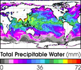
PRECIPITABLE WATER
Total precipitable water from the Advanced Microwave Sounding Unit (AMSU) aboard the NOAA 15 satellite. The AMSU instrument aboard the Aqua satellite will complement NOAA's AMSU instruments, resulting in a better understanding of the Earth's water cycle. (Image courtesy of NOAA.)
Related Links:
 The Hydrologic Cycle - A Multi-Phased Journey
Countries by Continent
Based on the seven-continent model, and grouping islands with adjacent continents, Africa has the most countries with 54. Europe contains 49 countries and Asia 48, but these two continents share five countries: Azerbaijan, Georgia, Kazakhstan, Russia, and Turkey. North America consists of 23 sovereign states, Oceania has 14, and South America 12. >>> Find out more...Great Waterways
Launch your own adventure along North America's original highways. The Great Lakes Waterway - The Great Lakes Waterway is a system of natural channels and artificial canals which enable navigation between the North American Great Lakes. The Intracoastal Waterway (ICW) - The Intracoastal Waterway is a 4,800 km (3,000 mile) long recreational and commercial waterway along the Atlantic and Gulf coasts of the United States. Some lengths of the ICW are natural and others are manmade.
RomWell Craft Pages
Surprise your loved ones with great craft creations, decorate your house, or make unique gifts for any occasion and create ultimate gift giving experience. Save money, spend a quality time with your dearest ones, and have fun doing great craft for any occasion!
Find out more
Browse RomWell Real Cooking