TRAVEL
enhance your experience...
KNOWLEDGE
make it much more comfortable...
INFORMATION
helps you to find things...
RomWell Travel Advisory
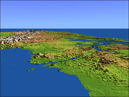
This perspective view shows the Panama Canal with the Gulf of Panama in the foreground and the Caribbean Sea in the distance. The canal runs northwest-southeast from the city of Colon on the Atlantic side to Panama City on the Pacific side.
Water levels are maintained along its length by three reservoirs, the largest of which is Lake Gatun, visible at the right center of the image. Built by the U.S. Army Corps of Engineers between 1904 and 1914, the canal extends for approximately 50 miles, and is widely considered to be one of the world’s great engineering achievements. Learn more...
This shaded relief perspective view was generated using topographic data from the Shuttle Radar Topography Mission (SRTM). A computer-generated artificial light source illuminates the elevation data to produce a pattern of light and shadows.
Image Courtesy SRTM Team NASA/JPL/NIMA
Slopes facing the light appear bright, while those facing away are shaded. On flatter surfaces, the pattern of light and shadows can reveal subtle features in the terrain. Colors show the elevation as measured by SRTM, and range from green at the lowest elevations to white at the highest elevations.
The rainforests of Panama, in particular, are some of the world’s most biologically diverse areas. Chagres National Park, situated east of Gatun Lake and the northern half of Panama Canal, has 1,185 species of plants, 130 of which are unique to that area.
Panama’s rainforests are home to many mammals that migrated from both North and South America. Among these species are jaguars, tapirs, deer, sloths, anteaters, and armadillos. There are also 650 species of birds and 93 amphibian species in the Panama Canal watershed. Learn more...
Surprise your loved ones with great craft creations, decorate your house, or make unique gifts for any occasion and create ultimate gift giving experience. Save money, spend a quality time with your dearest ones, and have fun doing great craft for any occasion!
Find out more