TRAVEL
enhance your experience...
KNOWLEDGE
make it much more comfortable...
INFORMATION
helps you to find things...
RomWell Travel Advisory
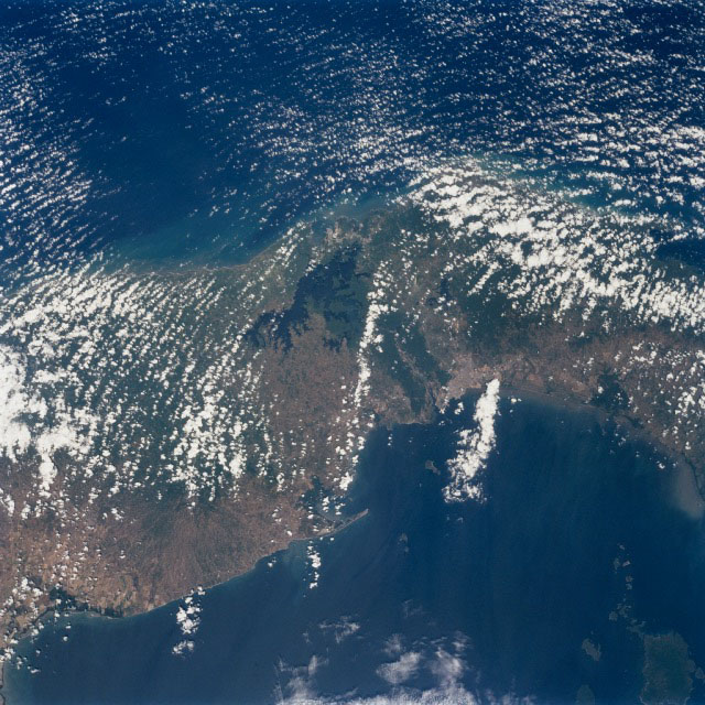
The Panama Canal Zone extends 5 miles (8 km) on either side of the Panama Canal. The forested zone acts as a buffer for the canal to help prevent erosion and sediment from clogging the canal.
Most of the countryside on both sides of the Canal Zone has been deforested to make way for large ranches and the raising of cattle. Though some sedimentation is occurring, dredging of the canal keeps the passage clear.
The Panama Canal is 40 miles (64 km) long including dredged approach channels at each end. With the Caribbean Sea covering the upper portion of the image and the Pacific Ocean covering the lower portion of the image, the canal traverses the Isthmus of Panama in a northwest to southeast direction.
Gatun Lake, one of the largest artificial lakes in the world, is visible at the north end of the Canal Zone. Panama City (light-colored grayish area) is discernible to the right of the canal at its southern entrance from the Pacific Ocean. In 1996, 15,000 ships traveled through the canal, an average of 42 ships per day. Passage through the canal requires 7 to 8 hours.
Image: Panama Canal Zone, Panama; Near the center of this north-looking image, the forested area of the Panama Canal Zone can be seen.
Image From: Image Science and Analysis Laboratory, NASA-Johnson Space Center.
Surprise your loved ones with great craft creations, decorate your house, or make unique gifts for any occasion and create ultimate gift giving experience. Save money, spend a quality time with your dearest ones, and have fun doing great craft for any occasion!
Find out more